
Kooperationspartner

Der Überblick "RIS-COMPACT" beruht auf dem "Regionalkundlichen Informationssystem (RIS)" und ist eine Initiative des Regionalverbandes Ruhr (RVR).
This survey RIS COMPACT is based on the Regional Information System "RIS" (Regionalkundliches Informationssystem) and is an initiative of the Regionalverband Ruhr/RVR.
Main topic: Fundamentals and beginnings
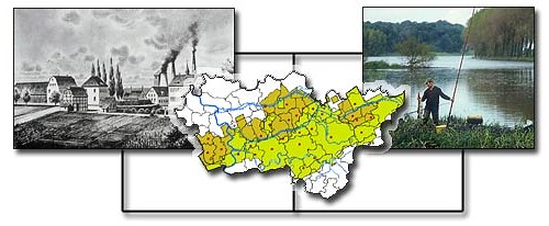
RVR Fotoarchiv, Kollage Autorenteam
Subtopic: Geographical location and development of settlement
The progress of the Ruhr has been made possible by a bundle of varied factors of which the good geographical situation and the physical equipment are the most important ones. Already under the reign of Charles the Great Franconian royal courts have been founded along the eastbound arterial road, the via regia, in the course of the wars against the Saxons. From mid-8th century to c. 890 Duisburg, Recklinghausen, Bochum, Dortmund and other places have been founded. Religious centres were Werden Abbey and the noble collegiate church of Essen.
From the 14th to the 16th century the demand for agricultural products expressed by the northern Hanseatic towns caused the foundation of 16 Hanse towns in the fertile Hellweg Börde. With the Hanse declining, however, the formerly flourishing towns turned into insignificant smallholders? towns. Their hinterlands were reduced to the Bergisch-Märkisch area with its small iron industries. It was not before the 18th century that the establishing of a regular post coach services paved the way to moderate development impulses.
The location at the crossing of European military roads and trading routes influenced the preindustrial development of settlements. This location received new impulses by the classical ?Blue Banana? planning approach (English Midlands ? London ? Netherlands ? Rhine valley - Northern Italy) as well as by the ?Yellow Banana? that has been outlined as a West-East axis after the late 1980s opening of Eastern Europe. Both these spatial orientations give growth impulses for trade and traffic in the Ruhr, particularly in the field of logistics.
Subtopic: Coal, Iron and Steel
Of remarkable importance were the coal measures that crop out in the south but dive down to more than 1000 metres in the north. It was not before the conveying technology had developed (shaft mining, controlled raising of water etc) that deeper and more valuable coal seams could be tapped. Both the chemical industry (coal by-products) and the coke-based production of steel took the profits. The carboniferous geology caused the northward movement of coal mining that was followed by the development of settlement. Adjusted to the geological conditions the coal mines also spreading over the boggy areas of the Emscher valley that had deterred any preindustrial settlement and were still affected by annual flooding and epidemic diseases. Settlements for thousands of miners grouped around the mines.
Unlike the resource-orientated coal mining, the iron and steel industry was labour-oriented and preferred sites around the existing cities.
In this chapter the early times of iron smelting and the pre-industrial phases of pig iron production are outlined as well as the differences between iron and steel, the various steel qualities and alloys, various steel producing processes and the use of steel. Based on the deep-lying seams of rich and gas coals, coke caused the coking-plant technologies since mid-19th century and thereby the regional boom of the coal and steel industries.
Subtopic: Borderlines and administrative boundaries
The Ruhr area is not a natural landscape nor is it a regional entity grown over centuries. Industrialisation has been superimposed on historical regions that are reflected today by the Landschaftsverbände of Westphalia and the Rhineland. For decades political decisions have successfully prevented the comprehensive administrative unit ?Region Ruhr? to come into existence. To the contrary, the region is rather intersected by the boundaries of three regional administrative bodies (Regierungsbezirke) that heteronomously influence the Ruhr from Düsseldorf, Arnsberg and Münster.
Whereas the political entity has been prevented from outside, the regional polycentric structure is connected by a variety of intraregional interrelations. Most of the settlement nuclei had a rapid start, achieved charters and very often grew explosively. But despite of various mergers of local authorities, e.g. the mid-1970s administrative restructuring, many of these units were hardly able properly to provide urban functions or to act as central places ? they were too large to be a village but too small to be a city, an area of 1000 industrial villages came into being. This structure may have fuelled the still existing local egoisms (parish pump politics) and the lasting competition for inhabitants, companies and urban functions.
Today the Ruhr area includes 12 cities in the core and four fringe districts each of them comprising some smaller cities. In the given interwoven urban fabric the borders between the various local units can often only be recognized by the place name signs. The separating functions of the regional green belts that had been laid out in 1920 by the former ?Siedlungsverband? could only be retained in parts. Very often these free spaces have be welcomed to lay out new railway tracks, motorways and high voltage lines and to develop leisure centres, housing quarters and university sites.
To the abstracts of other main chapters:
2. The era of the coal and steel industry
3. Renewing the infrastructure
4. Renewing urban areas
5. Renewing the economy
6. Perspectives for the future
2. The era of the coal and steel industry
3. Renewing the infrastructure
4. Renewing urban areas
5. Renewing the economy
6. Perspectives for the future